[ЕЖРЯ] КЛДыЧа ПЌБИЦР, А МіРЇ БтЗЯЧЯДТ РњКёПы МОМ АГЙп
МіРЇ МОМ - ХТОч РќСіЗЮ РлЕПЧв Мі РжРИИч РЏСі КИМі ОјРЬ ПЯРќШї ЕЖИГРћРИЗЮ РлЕП РЬ АЁДЩЧЯДй. [ЛчСјСІАј = Makan Karegar/University of Bonn]
КЛДыЧа(University of Bonn)РЧ ПЌБИПјЕщРК КёПы ШПРВРћРИЗЮ АРЧ МіРЇИІ 24НУАЃ И№ДЯХЭИЕЧв Мі РжДТ МОМИІ АГЙпЧпРИИч, РЬ МОМДТ СіПЊ РќУМРЧ ШЋМі АцАэ НУНКХлПЁ РћЧеЧЯДйАэ ЙрЧћДй. РЬ ПЌБИДТ ЁКМіРкПј ПЌБИ(Water Resources Research)ЁЛ РњГЮПЁ АдРчЕЦДй.
МіЗЮРЧ МіРЇИІ АсСЄЧЯДТ ЙцЙ§ПЁДТ ИХПь АЃДмЧб ЙцЙ§(ОпЕхЗЮ НКЦН ЖЧДТ НКХЧ АдРЬСі)КЮХЭ УЗДм ЗЙРЬДѕ МжЗчМЧПЁ РЬИЃБтБюСі БЄЙќРЇЧЯДй. БзЗЏГЊ ДыКЮКаРЧ УјСЄ РхФЁДТ ГєРК МіРЇПЁ СїСЂ ГыУтЕЧОю МеЛѓЕЩ Мі РжАэ, ИЙРК РхФЁАЁ СіМгРћРЮ И№ДЯХЭИЕРЛ ЧуПыЧЯСі ОЪРИИч, ПјАн ЦЧЕЖРЬ ОюЗЦАХГЊ ГЪЙЋ КёНЮДйДТ ДмСЁРЬ РжДй.
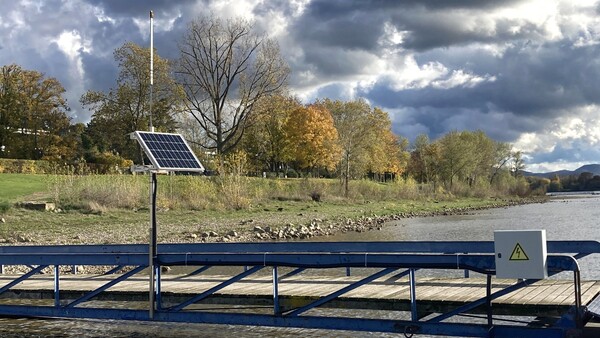
БзЗЏГЊ ЖѓРЮ А ЧЯЗљ КЃМП(Wesel)ПЁМДТ РЬЗЏЧб ДмСЁРЬ ОјДТ УјСЄ РхФЁАЁ РЬЙЬ 2Гт ЕПОШ ЛчПыЕЧАэ РжДй. КёПы ШПРВРћРЬАэ НХЗкЧв Мі РжРИИч, И№ЙйРЯ ХыНХРЛ ХыЧи ЦђАЁ МОХЭЗЮ СіМгРћРИЗЮ МіРЇИІ РќМлЧв Мі РжДй. РЬДТ РЬЗЏЧб МОМАЁ ШЋМі Йз АЁЙГ АцКИ НУНКХлРЛ РЇЧб СЖЙаЧЯАд КаЛъЕШ ГзЦЎПіХЉИІ СІАјЧЯДТ ЕЅ РћЧеЧЯДйДТ АЭРЛ РЧЙЬЧбДй.
КЛ ДыЧаБГРЧ СіИЎСЄКИПЌБИМв(Institute of Geodesy and Geoinformation)РЧ ИЖФ ФЋЗЙАЁИЃ ЙкЛч(Dr. Makan Karegar)ДТ "ПьИЎ РхФЁРЧ ЧйНЩРК РњАЁЧќ GNSS МіНХБтПЭ ОШХзГЊРЬДй"Ич, "РЬАЭРК ХыЛѓРћРИЗЮ Ию ЙЬХЭРЧ СЄШЎЕЕЗЮ РкНХРЧ РЇФЁИІ АсСЄЧв МіРжДТ МОМРЬДй. РЬАЭРК ЙЬБЙ GPS РЇМКАњ ЗЏНУОЦ ДыРР РЇМКРЮ GLONASSИІ ЛчПыЧЯПЉ МіЧрЧбДй. БзЗЏГЊ РЇМК НХШЃДТ А ЧЅИщ РЇПЁ РжДТ GNSS ОШХзГЊРЧ ГєРЬИІ УјСЄЧЯДТ ЕЅПЁЕЕ ЛчПыЕЩ Мі РжДй"Аэ МГИэЧпДй.
ЙнЛчЕШ НХШЃДТ МіРЇПЁ ДыЧб СЄКИИІ СІАјЧбДй.
РЬДТ РЇМКРЬ РќДоЧЯДТ РќЦФАЁ ОШХзГЊПЁ РЧЧи КЮКаРћРИЗЮ СїСЂ ЦїТјЕЧБт ЖЇЙЎРЬДй. ГЊИгСіДТ СжКЏ ШЏАц(РЬ АцПь МіИщ)ПЁМ ЙнЛчЕЧОю ПьШИИІ ХыЧи МіНХБтПЁ ЕЕДоЧбДй. ЕћЖѓМ РЬ ЙнЛчЕШ КЮКаРК Дѕ ПРЗЁ РЬЕПЧбДй. СїСЂ МіНХЕШ НХШЃАЁ СпУИЕЩ ЖЇ, АЃМЗРЬЖѓДТ ЦЏСЄ ЦаХЯРЛ ЧќМКЧбДй. РЬАЭРК ОШХзГЊПЭ МіРЇ ЛчРЬРЧ АХИЎИІ АшЛъЧЯДТ ЕЅ ЛчПыЧв Мі РжДй.
ФЋЗЙАЁИЃ ЙкЛчДТ "ПьИЎДТ GNSS ОШХзГЊИІ ДйИЎ, АЧЙА ЖЧДТ А ПЗРЧ ГЊЙЋГЊ ПяХИИЎ Ею ОюЖВ БИСЖЙАПЁЕЕ КЮТјЧв Мі РжДй"Ич, "АХБтМКЮХЭ БзАЭРК СЂУЫ ОјРЬ 24НУАЃ ГЛГЛ АРЧ МіРЇИІ ЦђБе Ор 1.5cm РЬГЛЗЮ УјСЄЧв Мі РжДй. ЖЧЧб БиНЩЧб ШЋМіАЁ ЙпЛ§Чв АцПь МеЛѓЕЩ АЁДЩМКРЬ РћДй"Аэ МГИэЧпДй. ФЋЗЙАЁИЃ ЙкЛчДТ РЬОю "РЬ ЙцЙ§РЧ СЄШЎЕЕДТ ЗЙРЬДѕ БтЙн МОМРЧ СЄШЎЕЕПЭ РЯФЁЧЯСі ОЪДТДй. БзЗЏГЊ ПыЕЕПЁДТ УцКаШї РћЧеЧЯИч, 150РЏЗЮ ЙЬИИРИЗЮ ДйИЅ СІЧААЁ КёБГ НУ ЛѓДчШї РњЗХЧЯДй"Аэ ЕЁКйПДДй.
GNSS ОШХзГЊДТ ЖѓСюКЃИЎ ЦФРЬ(Raspberry Pi)ЖѓАэ КвИЎДТ ИЖРЬХЉЗЮФФЧЛХЭПЁ ПЌАсЕХ РжДй. СіИЎСЄКИПЌБИМвРЧ ХЉИЎНКЦО ЖѓНМ( Dr. Kristine Larson) БГМіДТ "РЬ РхФЁДТ РлРК НКИЖЦЎЦљ ХЉБтПЁ КвАњЧЯСіИИ ПјНУ ЕЅРЬХЭПЁМ МіРЇИІ АшЛъЧв Мі РжДТ УцКаЧб МКДЩРЛ АЎУпАэ РжДй"Аэ МГИэЧпДй. РЏПЌМКАњ РњРќЗТ МвИ№ ДіКаПЁ ИЖРЬХЉЗЮФФЧЛХЭДТ ДйОчЧб ЧСЗЮСЇЦЎИІ НЧЧіЧЯБт РЇЧи ИЖРЬХЉЗЮФФЧЛХЭИІ ЛчПыЧЯДТ ОжШЃАЁЕщ ЛчРЬПЁМ ИХПь РЮБтАЁ РжДй. БзАЭРК ХТОч РќСіЗЮ РќЗТРЛ АјБоЙоРЛ Мі РжРИИч, ПЯРќШї ЕЖИГРћРИЗЮ РлЕПЧв Мі РжДй. ЖЧЧб И№ЙйРЯ ГзЦЎПіХЉИІ ХыЧи ЕЅРЬХЭИІ РќМлЧв МіЕЕ РжДй.
РЮХЭГнЛѓРЧ КЙСІ СЄКИ
ЖѓНМ БГМіДТ "ПьИЎАЁ РлМКЧб МвЧСЦЎПўОюДТ ПРЧТ МвНКРЬДй"Ич, "ЕћЖѓМ ДЉБИГЊ ЙЋЗсЗЮ ЛчПыЧв Мі РжДйАэ" ИЛЧпДй. ПЌБИПјЕщРК ЖЧЧб БзЕщРЧ ЧСЗЮСЇЦЎПЁ ДыЧб И№Еч СЄКИИІ РЮХЭГнПЁМ ЛчПыЧв Мі РжЕЕЗЯ ЧпДй. ЕћЖѓМ РЬЧи ДчЛчРкДТ УјСЄ РхФЁИІ НБАд РчЧіЧв Мі РжДй.
БзЗЏГЊ РЬ АњСЄПЁДТ Чб АЁСі ДмСЁРЬ РжДй. ЦјРЬ 40ЙЬХЭ РЬЛѓРЮ АПЁИИ РћЧеЧЯДй. ФЋЗЙАЁИЃ ЙкЛчДТ "РЬАЭРК ОШХзГЊАЁ ЙнЛчЕШ РЇМК НХШЃИІ МіНХЧв Мі РжДТ АЁРх РлРК ЙнАцРЬДй"ЖѓИч, "ИИОр МіЗЮАЁ ГЪЙЋ СМРИИщ ЙнЛчЕШ НХШЃРЧ ДыКЮКаРЬ РАСіПЁМ ПТДй"Аэ ИЛЧпДй. БзЗЏГЊ АќЗУЕШ ЛчЖїЕщРК ЦђАЁ ФкЕхИІ ДѕПэ УжРћШЧв АшШЙРЬДй. БзЕщРК РЬАЭРЬ 2021ГтПЁ НЩАЂЧб ШЋМіИІ АцЧшЧб ЕЖРЯРЧ ОЦИЃА(Ahr)Ањ ААРК Дѕ РлРК АПЁ ДыЧи НХЗкЧв Мі РжДТ АсАњИІ ОђРЛ Мі РжБтИІ ШёИСЧбДй.
[ПјЙЎКИБт]
Low-cost sensor records the level of rivers
Measurement method developed at the University of Bonn could be suitable for flood warning systems
Researchers at the University of Bonn have developed a method that allows the water level of rivers to be monitored around the clock. The cost-effective sensor is for instance suitable for area-wide flood warning systems. The study has been published in the journal Water Resources Research.
There is a wide range of methods to determine the level of a watercourse - from very simple ones (by yardstick or staff gauge) to advanced radar solutions. But they all have a catch: Most measuring devices can be damaged due to direct exposure to the high water level, many do not allow continuous monitoring, remote reading is difficult or they are simply too expensive.
In Wesel on the Lower Rhine, however, a measuring device that does not have these disadvantages has already been in service for two years: It is cost-effective, reliable and capable of continuously transmitting the water level to an evaluation center via mobile communication. In principle, this means that such a sensor is suitable for providing a densely-distributed network for flood and drought warning systems.
"The core of our device is a low-cost GNSS receiver and antenna," explains Dr. Makan Karegar of the Institute of Geodesy and Geoinformation at the University of Bonn. This is a sensor that can conventionally determine the position of its location with several meter accuracy. It does this using the US GPS satellites and their Russian counterparts, GLONASS. "However, satellite signals can also be used to measure the height of the GNSS antenna above the river surface," Karegar says.
Reflected signals provide information on the water level
This is because the waves transmitted by the satellites are partially picked up directly by the antenna. The rest is reflected from the nearby environment (in this case the water surface) and reaches the receiver via detour. This reflected part therefore travels longer. When superimposed on the directly received signal, it forms certain patterns called interference. These can be used to calculate the distance between the antenna and the water level.
"We can attach the GNSS antenna to any structure, whether it's a bridge, a building, or a tree or fence next to the river," Karegar explains. "From there, it can measure the river level around the clock without contact - to within around 1.5 centimeters on average. And yet it is less likely to be damaged during extreme flooding events." The accuracy of the method does not match that of a radar-based sensor. However, it is completely sufficient for the intended use. At just under 150 euros, the device is also considerably cheaper than its advanced counterpart.
The GNSS antenna is connected to a microcomputer called a Raspberry Pi. "The device is about the size of a small smartphone; yet it has enough power to calculate water levels from raw data," reports Prof. Dr. Kristine Larson of the Institute of Geodesy and Geoinformation. Thanks to its flexibility and low-power consumption, the microcomputer is very popular among hobbyists, who use it to realize a wide variety of projects. It can be powered by solar cells and then works completely stand alone. It can also transmit its data via mobile network.
Reproduction information on the Internet
"The software we wrote is open source," Larson explains. "So it can be used by anyone for free." The researchers also make all the information about their project available on the Internet. Interested parties can therefore easily reproduce the measuring device.
However, the process has one disadvantage: It is only suitable for rivers with width of at least 40 meters. "This is the smallest radius from which the antenna can receive the reflected satellite signal," Karegar says. "If the watercourse is too narrow, most of the reflected signals come from the land." But those involved plan to further optimize their evaluation code. They hope that this will enable them to obtain reliable results for smaller rivers such as the Ahr in Germany, which experienced severe flooding in 2021.
[УтУГ = University of Bonn(https://www.uni-bonn.de/en/news/272-2022) / 2022Гт 11Пљ 23РЯ]